![](/images/other/stat-length.png)
![Tour Wandern Le Vernet - Les 2 vallées: de l'Allier et du Sichon) - Photo](https://media.geolcdn.com/t/1900/400/ext.pjpeg?maxdim=2&url=https%3A%2F%2Fservices.sitytrail.com%2FGeolivesWS%2FDownloadMedia.ashx%3FTrailID%3D105252%26Media%3D8915_6.jpg)
Les 2 vallées: de l'Allier et du Sichon)
tracegps
Benutzer
![Länge](/images/other/stat-length.png)
![Maximale Höhe](https://static1.geolcdn.com/siteimages/upload/files/1508320355ic_sort_altitude_max_24dp.png)
![Positive Höhendifferenz](https://static1.geolcdn.com/siteimages/upload/files/1508320355ic_sort_den_pos_24dp.png)
![Km-Effort](/images/other/stat-length.png)
![Min. Höhe](https://static1.geolcdn.com/siteimages/upload/files/1508320355ic_sort_altitude_min_24dp.png)
![Negative Höhendifferenz](https://static1.geolcdn.com/siteimages/upload/files/1508320355ic_sort_den_neg_24dp.png)
![Boucle](https://static1.geolcdn.com/siteimages/upload/files/16400158638029165_repeat_loop_refresh_sync_direction_icon.png)
![Wandern](https://static1.geolcdn.com/sitytour/trail-icons/101.png)
2h30
Schwierigkeit : Medium
![Scannen Sie diesen QR-Code, um die Tour in der SityTrail-Anwendung zu öffnen](https://capi.geolives.com/qq0zvz2zws4bq2lad0pu/sitytour/trails/105252/qr.png?size=200)
Kostenlosegpshiking-Anwendung
Über SityTrail
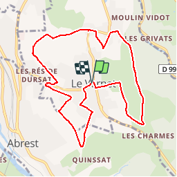
Tour Wandern von 10,3 km verfügbar auf Auvergne-Rhone-Alpen, Allier, Le Vernet. Diese Tour wird von tracegps vorgeschlagen.
Beschreibung
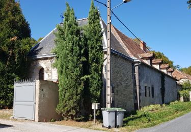
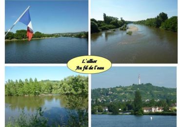
Départ : LE VERNET (sur les hauteurs de Vichy). La commune est proche du parc naturel régional Livradois-Forez à environ 13 km. Tout proche le "site des Hurlevents" (Tour de Télécommunications) où de la table d'orientation, vous prendrez le temps d'admirer les somptueux panoramas sur la vallée de l'Allier, les monts du Livradois-Forez et les monts d'Auvergne. Départ du petit parking gratuit au pied de l'église qui n'est plus un lieu de culte mais reconvertie en salle des fêtes et d'exposition. Deux vallées bordent ce parcours : la vallée de "l'Allier" à l'Ouest, large et sinueuse conduisant les regards vers les Puys d'Auvergne ; la vallée du "Sichon" à l'Est, profonde et boisée s'enfonçant dans la Montagne Bourbonnaise. Bien que vallonné, ce parcours ne présente aucune difficulté majeure. Topoguide : "Autour de Vichy", 35 balades et randonnées (à pied et à VTT): disponible à l'O.T et dans les librairies de Vichy.
Ort
Kommentare
Touren in der Umgebung
![Tour Laufen Bellerive-sur-Allier - jour 9 CAP Jeanot - Photo](https://media.geolcdn.com/t/375/260/ext.jpg?maxdim=2&url=https%3A%2F%2Fmedia.geolcdn.com%2Ff%2F7d17c922-815e-47f7-82ec-b4d7cd4fb976.jpg)
![Laufen Laufen](https://static1.geolcdn.com/sitytour/trail-icons/103.png)
Laufen
![](/images/other/stat-length.png)
![](https://static1.geolcdn.com/siteimages/upload/files/16400158638029165_repeat_loop_refresh_sync_direction_icon.png)
![Tour Mountainbike Vichy - Rives et Boires de l'Allier - Photo](https://media.geolcdn.com/t/375/260/ext.jpg?maxdim=2&url=https%3A%2F%2Fservices.sitytrail.com%2FGeolivesWS%2FDownloadMedia.ashx%3FTrailID%3D105254%26Media%3D8917_6.jpg)
![Mountainbike Mountainbike](https://static1.geolcdn.com/sitytour/trail-icons/202.png)
Mountainbike
![](/images/other/stat-length.png)
![](https://static1.geolcdn.com/siteimages/upload/files/16400158638029165_repeat_loop_refresh_sync_direction_icon.png)
![Tour Wandern Le Vernet - Les Bois Dieux - Photo](https://media.geolcdn.com/t/375/260/ext.jpg?maxdim=2&url=https%3A%2F%2Fstatic1.geolcdn.com%2Fsiteimages%2Fupload%2Ffiles%2F1553511878bg_sport_marche.png)
![Wandern Wandern](https://static1.geolcdn.com/sitytour/trail-icons/101.png)
Wandern
![](/images/other/stat-length.png)
![](https://static1.geolcdn.com/siteimages/upload/files/16400158638029165_repeat_loop_refresh_sync_direction_icon.png)
![Tour Wandern Vichy - Vichy - Photo](https://media.geolcdn.com/t/375/260/ext.jpg?maxdim=2&url=https%3A%2F%2Fmedia.geolcdn.com%2Ff%2F9c126706-e583-4f12-a13f-a3db3d21e976.jpg)
![Wandern Wandern](https://static1.geolcdn.com/sitytour/trail-icons/101.png)
Wandern
![](/images/other/stat-length.png)
![](https://static1.geolcdn.com/siteimages/upload/files/16400158638029165_repeat_loop_refresh_sync_direction_icon.png)
![Tour Wandern Le Vernet - Le Vernet - Photo](https://media.geolcdn.com/t/375/260/ext.jpg?maxdim=2&url=https%3A%2F%2Fmedia.geolcdn.com%2Ff%2F72a3d05d-0419-4530-af61-0d395eb14378.png)
![Wandern Wandern](https://static1.geolcdn.com/sitytour/trail-icons/101.png)
Wandern
![](/images/other/stat-length.png)
![](https://static1.geolcdn.com/siteimages/upload/files/16400158638029165_repeat_loop_refresh_sync_direction_icon.png)
![Tour Wandern Saint-Yorre - CLD - GM- Le 22-03-2022 - Photo](https://media.geolcdn.com/t/375/260/ext.jpg?maxdim=2&url=https%3A%2F%2Fmedia.geolcdn.com%2Ff%2Fe06fa55f-8e9d-4a08-aab3-9e64b2e66128.jpg)
![Wandern Wandern](https://static1.geolcdn.com/sitytour/trail-icons/101.png)
Wandern
![](/images/other/stat-length.png)
![](https://static1.geolcdn.com/siteimages/upload/files/16400158638029165_repeat_loop_refresh_sync_direction_icon.png)
![Tour Wandern Vichy - Vichy - Photo](https://media.geolcdn.com/t/375/260/ext.jpg?maxdim=2&url=https%3A%2F%2Fmedia.geolcdn.com%2Ff%2F919bfe1b-8f52-4d28-8684-d913ba69e93e.png)
![Wandern Wandern](https://static1.geolcdn.com/sitytour/trail-icons/101.png)
![Tour Wandern Vichy - vichy Historique - Photo](https://media.geolcdn.com/t/375/260/ext.jpg?maxdim=2&url=https%3A%2F%2Fmedia.geolcdn.com%2Ff%2F8b2a5564-29fa-4313-8e73-c6f9f43b6f78.jpg)
![Wandern Wandern](https://static1.geolcdn.com/sitytour/trail-icons/101.png)
Wandern
![](/images/other/stat-length.png)
![](https://static1.geolcdn.com/siteimages/upload/files/16400158638029165_repeat_loop_refresh_sync_direction_icon.png)
![Tour Fahrrad Vichy - Vichy Oleron Rochefort - Photo](https://media.geolcdn.com/t/375/260/ext.jpg?maxdim=2&url=https%3A%2F%2Fservices.sitytrail.com%2FGeolivesWS%2FDownloadMedia.ashx%3FTrailID%3D103802%26Media%3D6576_1.jpg)
![Fahrrad Fahrrad](https://static1.geolcdn.com/sitytour/trail-icons/200.png)
Fahrrad
![](/images/other/stat-length.png)
![](https://static1.geolcdn.com/siteimages/upload/files/16400158638029165_repeat_loop_refresh_sync_direction_icon.png)
Très bonne application